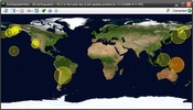
EarthquakeView is a tool to keep you informed at all times of the movements of the earth happening around the planet.
The application accesses the information provided by the US government through the website earthquake.usgs.gov.
Advertisement
EarthquakeView highlights the areas affected by earthquakes using a circle with different colors.
The color legend makes reference to earthquakes that took place in the last hour, the day before, or during the past week.
If you click one of the movements, you can also access the satellite image for the area thanks to its interaction with Microsoft Virtual Earth.


Comments
There are no opinions about EarthquakeView yet. Be the first! Comment